
3D point cloud annotation is the process of adding structured labels bounding cuboids, semantic class tags, lane markings, and object identities to three-dimensional spatial data captured by LiDAR sensors, depth cameras, and stereo vision systems. It is how autonomous vehicles, robots, and spatial computing systems learn to perceive and navigate the physical world.
Unlike image annotation that operates on flat pixel grids, LiDAR annotation works with unordered sets of X, Y, Z coordinates representing millions of points in three-dimensional space. Each point carries position data and often additional attributes like intensity (reflectivity) or return number. Standard convolutional neural networks cannot process this data directly specialized architectures like PointNet, VoxelNet, and PointPillars are required, and each demands different point cloud labeling approaches.
The stakes are among the highest in all of AI. LiDAR data labeling autonomous driving trains the perception systems that make split-second decisions about pedestrians, vehicles, and obstacles. A mislabeled cuboid or an incorrect segmentation boundary can propagate through the planning stack and create dangerous driving decisions. As Steve Nemzer of TELUS Digital noted in April 2026, “The gap between an autonomous system that performs well in simulation and one that operates reliably in the real world almost always traces back to data not the volume of data, but the precision of it.”
This guide covers every major 3D point cloud annotation method, from cuboid labeling through sensor fusion annotation, with the depth and technical specificity this safety-critical domain demands.
What Are Point Clouds and Why Do They Require Specialized Annotation?
A point cloud is a collection of data points in three-dimensional space. Each point has X, Y, and Z coordinates representing its position relative to the sensor. Modern automotive-grade LiDAR sensors fire hundreds of thousands of laser pulses per second, measuring how long each pulse takes to bounce back from surfaces in the environment. The result is a dense 3D representation of the scene millions of points per frame capturing the shape, position, and distance of every object the laser reaches.
Point clouds differ from images in fundamental ways that affect annotation. They are unordered there is no pixel grid, no fixed spatial structure. They are sparse at distance a car at 10 meters may consist of thousands of points with a clearly visible outline, while the same car at 100 meters may appear as a handful of scattered dots. It contain occlusion gaps lasers cannot penetrate objects, so anything behind a truck or wall simply does not exist in the data.
These properties make LiDAR annotation significantly more challenging than 2D image labeling. Annotators must navigate and interpret 3D space, mentally reconstruct objects from sparse and partial point distributions, and maintain spatial accuracy across all three axes. Industry estimates indicate that point cloud labeling takes 6–10x longer per frame than equivalent 2D image annotation due to this spatial complexity.
3D Bounding Box Annotation: The Standard for Object Detection
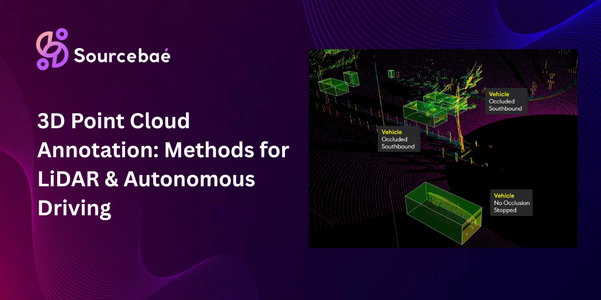
3D bounding box annotation (also called 3D cuboid annotation) is the most widely used 3D point cloud annotation method. It places a rectangular volume a cuboid around each object of interest, defining its position, dimensions, and orientation in three-dimensional space.
How it works
The annotator identifies an object in the point cloud a vehicle, pedestrian, cyclist, or traffic sign and draws a cuboid tightly around its visible points. Each 3D bounding box annotation captures seven parameters: X, Y, Z position (the cuboid’s center point), length, width, and height (the cuboid’s dimensions), and heading angle (the cuboid’s orientation, indicating which direction the object faces).
Getting the orientation right is critical. A car’s heading determines whether it is approaching, receding, or crossing the ego vehicle’s path information the planning system uses to predict trajectories and make safe decisions. A cuboid with an incorrect heading angle teaches the model the wrong motion pattern.
When to use 3D bounding box annotation
3D bounding box annotation is the standard for object detection training in autonomous driving, robotics, and drone navigation. It tells the model where things are, how big they are, and which direction they face. Use it when your perception model needs to detect and localize objects in 3D space but does not require pixel-level (or point-level) boundary precision.
Limitations
Cuboids include empty space a 3D bounding box annotation around a pedestrian captures air above their head and beside their shoulders. For applications requiring precise volumetric understanding (robotic grasping, collision margin calculation), segmentation provides higher accuracy. Cuboids also struggle with non-rigid or irregularly shaped objects like vegetation, debris, or deformable loads on trucks.
3D Semantic Segmentation Labeling: Classifying Every Point
3D semantic segmentation labeling assigns a class label to every individual point in the cloud, creating a fully classified 3D scene. Instead of drawing boxes around objects, the annotator (or AI model) labels each point as road, sidewalk, vehicle, pedestrian, building, vegetation, traffic sign, or any other class in the taxonomy.
How it works
Every point in the cloud receives a class tag. The output is a color-coded 3D scene where each color represents a specific class similar to 2D semantic segmentation but in three dimensions. 3D semantic segmentation labeling provides a complete understanding of the environment at the point level, allowing the perception system to distinguish drivable surface from curb, sidewalk from building, and static objects from dynamic agents.
When to use 3D semantic segmentation labeling
3D semantic segmentation labeling is essential when the model needs full scene understanding not just “where are the objects?” but “what is every surface in the environment?” Key use cases include drivable area detection (identifying exactly which surfaces the vehicle can safely traverse), urban mapping and digital twin construction, terrain classification for off-road robotics, and environmental monitoring where every surface type must be cataloged.
Limitations
3D semantic segmentation labeling is the most time-intensive form of point cloud labeling. Labeling every point in a dense cloud with millions of points per frame is extraordinarily labor-intensive, even with AI-assisted pre-labeling. It also does not distinguish between individual instances all vehicle points receive the same “vehicle” label. When individual object identity matters (counting vehicles, tracking specific pedestrians), you need instance segmentation or cuboids on top of semantic labels.
Lane Marking and Road Infrastructure Annotation
Lane marking annotation labels the road infrastructure that autonomous vehicles need to understand for navigation lane boundaries, center lines, stop lines, crosswalks, turn arrows, and road edge markings. In point cloud data, these markings appear as reflectivity patterns on the ground plane, requiring annotators to identify them from intensity values rather than visual color.
How it works
Annotators trace polylines along lane boundaries and road markings in the point cloud, using intensity (reflectivity) data to distinguish painted markings from unmarked road surface. Each polyline receives a class label lane boundary, center line, stop line, crosswalk edge and attribute tags such as line type (solid, dashed, double) and lane direction.
Use cases
Lane detection is critical for keeping autonomous vehicles within their designated lane, executing lane changes, and navigating intersections. HD map construction depends on accurately annotated lane infrastructure. Advanced driver assistance systems (ADAS) use lane annotations for lane departure warnings and lane-keeping assist features.
Challenges
Lane markings are often faded, partially occluded by vehicles, covered by snow or water, or inconsistent across regions. LiDAR intensity data may not clearly distinguish markings in all weather or lighting conditions, making LiDAR annotation of lane markings one of the more subjective tasks in the autonomous driving pipeline. Combining LiDAR data with camera imagery through sensor fusion annotation significantly improves lane detection accuracy.
Sensor Fusion Annotation: Aligning LiDAR with Camera and Radar
Sensor fusion annotation is the process of creating a unified, cross-modal ground truth by aligning and synchronizing labels across multiple sensor types typically LiDAR, camera, and radar. No single sensor provides a complete picture: LiDAR delivers precise 3D spatial data but lacks color and texture. Cameras capture rich visual detail but cannot measure depth directly. Radar detects velocity and operates through adverse weather but has low spatial resolution.
How it works
Sensor fusion annotation requires that the same object be labeled identically across every sensor stream. A pedestrian identified in the LiDAR point cloud must correspond precisely to the same pedestrian in the camera frame and the radar return. This demands annotation platforms that support synchronized multi-modal display allowing the annotator to view 3D point clouds, 2D camera images, and radar data simultaneously and apply consistent labels across all modalities.
The technical challenge is cross-modal alignment. Each sensor has its own coordinate system, field of view, frame rate, and data format. Before annotation begins, the data streams must be calibrated and time-synchronized so that a label placed in the point cloud maps correctly to the corresponding pixel in the camera image.
Why sensor fusion annotation matters
The majority of production autonomous driving platforms use sensor fusion annotation as standard practice. Each sensor compensates for the others’ weaknesses LiDAR provides the spatial framework, cameras add visual context and color, radar adds velocity measurements and weather resilience. Without high-quality sensor fusion annotation that maintains cross-modal consistency, the perception model cannot learn to effectively fuse these inputs.
Challenges
Temporal synchronization between sensors is the primary technical hurdle. If the LiDAR and camera are not perfectly time-synced (to within milliseconds), moving objects appear in different positions across modalities, creating contradictory labels that confuse the fusion model. Calibration drift over time sensors shifting slightly in their mounting positions can also introduce misalignment that degrades annotation quality.
Ground Truth Generation: Building the Reference Standard
Ground truth in 3D point cloud annotation refers to the complete, validated set of labels against which a perception model’s predictions are evaluated. Its truth quality defines the ceiling of model performance a model cannot reliably exceed the accuracy of its training annotations.
For LiDAR data labeling autonomous driving, ground truth generation follows a rigorous multi-stage process. Initial annotation applies labels (cuboids, segmentation, lane markings) to each frame. Multi-pass review has a second annotator independently verify or correct the first annotator’s work. Expert adjudication resolves disagreements between annotators, particularly for edge cases like partially occluded objects or ambiguous class boundaries. Automated consistency checks validate temporal consistency (does an object’s cuboid move smoothly between frames?), spatial consistency (are cuboid dimensions physically plausible?), and cross-modal consistency (do LiDAR labels align with camera labels?).
Production autonomous driving programs typically require 99.5%+ annotation accuracy for safety-critical perception models. Achieving this threshold at scale across tens of thousands of frames per day from fleets of test vehicles requires purpose-built tooling, structured QA workflows, and experienced annotation teams with spatial reasoning expertise.
Key Challenges in 3D Point Cloud Annotation
3D point cloud annotation introduces challenges that 2D annotation does not face. Understanding these challenges is essential for teams building or procuring LiDAR annotation pipelines.
Sparsity at distance.
LiDAR point density decreases with distance from the sensor. Nearby objects are represented by thousands of points. Distant objects may consist of only a handful of scattered dots. Annotators must infer object boundaries from minimal data, requiring strong spatial reasoning and domain knowledge. This sparsity also means that point cloud labeling at long range is inherently less precise than at short range.
Occlusion and partial visibility.
Objects hidden behind other objects simply do not exist in the point cloud. A pedestrian partially occluded by a parked car appears as half a shape. Annotation guidelines must define how to handle partial objects: label only the visible portion? Estimate the full extent? Annotate and flag as “partially occluded”? Consistent handling of occlusion is one of the hardest aspects of building LiDAR annotation guidelines.
Weather degradation.
Rain, snow, fog, and dust significantly degrade LiDAR data quality. Laser beams reflect off water droplets and snowflakes, creating noise and false points. This complicates 3D bounding box annotation by obscuring object boundaries and increasing the number of artifacts that annotators must distinguish from real objects.
Massive data volumes.
A single autonomous test vehicle driving for one hour may produce tens of thousands of LiDAR frames, each containing millions of points. Fleet-scale data collection across multiple cities and weather conditions generates annotation volumes that require industrial-scale operations. LiDAR data labeling autonomous driving at production volume is a data operations challenge as much as an annotation challenge.
Temporal and relational consistency.
In 2026, the industry has shifted toward demanding “temporal and relational consistency” across annotation meaning that labels must not only be spatially accurate in individual frames but must maintain identity, motion coherence, and relational logic across entire sequences. An object’s cuboid must move smoothly between frames, its class label must remain consistent, and its spatial relationship to other objects must be physically plausible.
AI-Assisted 3D Annotation in 2026
Modern LiDAR annotation pipelines use AI-assisted pre-labeling to manage the enormous scale and complexity of 3D point cloud annotation.
Model-assisted pre-labeling generates initial cuboids and segmentation labels using pre-trained perception models. Industry reports indicate these models achieve approximately 80% accuracy on initial predictions, meaning annotators focus on correcting the remaining 20% rather than labeling from scratch boosting efficiency by 5x or more.
Temporal interpolation and tracking automates the propagation of labels across sequential frames. The annotator labels an object in the first and last frame of a sequence, and the tool’s interpolation algorithm fills in all intermediate frames while ensuring physically plausible motion trajectories.
Multi-sensor fusion workstations display LiDAR, camera, and radar data simultaneously in a single interface, allowing annotators to cross-reference modalities during sensor fusion annotation and eliminate visual blind spots that any single sensor creates.
However, AI-assisted tools still fail on novel object types outside their training distribution, heavily occluded objects with minimal visible points, rare edge cases (debris, unusual vehicles, construction equipment), and degraded sensor data from weather or calibration drift. Human expertise remains essential for production-quality 3D point cloud annotation, particularly in safety-critical autonomous driving applications.
Frequently Asked Questions
What is 3D point cloud annotation?
3D point cloud annotation is the process of adding structured labels to three-dimensional spatial data captured by LiDAR sensors, depth cameras, or stereo vision systems. Labels include 3D bounding cuboids around objects, semantic class tags on individual points, lane markings, and object tracking identities. It is the foundation of perception systems for autonomous vehicles, robotics, drones, and spatial computing any application where AI must understand depth, distance, and 3D spatial relationships.
What is LiDAR annotation used for?
LiDAR annotation trains perception models to detect, classify, and track objects in three-dimensional space. The primary application is LiDAR data labeling autonomous driving, where annotated point clouds teach self-driving systems to identify vehicles, pedestrians, cyclists, lane markings, and road infrastructure. Other major applications include warehouse robotics, drone navigation, urban digital twin construction, mining and surveying, and augmented reality spatial mapping.
What is 3D bounding box annotation?
3D bounding box annotation (cuboid annotation) places a rectangular 3D volume around each object of interest in a point cloud, defining its position, dimensions (length, width, height), and heading angle (orientation). It is the most widely used 3D point cloud annotation method for object detection. Each 3D bounding box annotation captures seven parameters that tell the perception model where an object is, how big it is, and which direction it faces critical for trajectory prediction and collision avoidance.
What is 3D semantic segmentation labeling?
3D semantic segmentation labeling assigns a class label to every individual point in a LiDAR point cloud, creating a fully classified 3D scene. Every point is labeled as road, sidewalk, vehicle, pedestrian, building, vegetation, or another predefined class. It provides complete scene understanding at the point level and is essential for drivable area detection, terrain classification, and urban mapping. 3D semantic segmentation labeling is the most time-intensive annotation method because it requires labeling millions of individual points per frame.
What is sensor fusion annotation?
Sensor fusion annotation creates a unified ground truth by aligning labels across multiple sensor types LiDAR, camera, and radar so that the same object is labeled identically in every data stream. A pedestrian in the point cloud must correspond precisely to the same pedestrian in the camera image and radar return. Sensor fusion annotation is standard practice in production autonomous driving because no single sensor provides a complete environmental picture. The primary challenges are temporal synchronization (sensors must be time-synced to within milliseconds) and calibration maintenance (sensors must remain spatially aligned over time).
How much does 3D point cloud annotation cost?
Point cloud labeling costs significantly more than 2D image annotation due to spatial complexity and the time required per frame. 3D bounding box annotation for autonomous driving typically costs $2–$8 per frame for outsourced work, depending on object density and class complexity. 3D semantic segmentation labeling can cost $10–$30+ per frame. Sensor fusion annotation (aligning LiDAR with camera and radar) adds 30–50% on top of single-modality costs. AI-assisted pre-labeling reduces these costs by up to 5x by generating initial labels at ~80% accuracy for human review and correction.
What tools support LiDAR annotation?
Leading platforms for LiDAR annotation in 2026 include Encord (best for AI-assisted 3D labeling with multi-sensor fusion), Scale AI (managed workforce for high-volume autonomous driving projects), CVAT (best open-source option with 3D cuboid support), Segments.ai (specialized in point cloud segmentation), Supervisely (flexible with on-premise deployment), and AWS SageMaker Ground Truth (best for teams in the AWS ecosystem). Key features to evaluate: 3D rendering performance with dense point clouds, temporal interpolation quality, multi-sensor fusion display, and integration with your perception model training pipeline.